True stories of explorers, spies & map-makers
At the turn of the 19th century, an unusual proposal was put forward to the British authorities in India, which neither they nor anyone else on the subcontinent were capable of fully comprehending


At the turn of the nineteenth century, an unusual proposal was put forward to the British authorities in India, which neither they nor anyone else on the subcontinent were capable of fully comprehending. In spite of this, the plan was approved, and in time its far-reaching consequences would be felt not only in India but right across the world. The proposal set out to measure the shape of the earth, while intricately mapping India—a scientific project on a scale not previously attempted anywhere on the planet. The idea’s originator was William Lambton, and the venture he began would be completed one day by his successor George Everest.
Lambton Arrives
Lambton was an officer in the East India Company’s army, like Everest, but both were first and foremost cartographers, who would make the mapping of India their life’s work. In its pursuit, they would travel over much of the subcontinent, including many of its lesser known and threatening regions, which would turn them into hardy explorers as well. While surveying in these remote areas, they were expected to gather intelligence about the people they encountered and their rulers. This included noting important commercial and military details, as their employer, the Survey of India, was administered by the Military Department. If need be, they could be recalled for soldiering at any time, as Lambton was on at least one occasion.
Little is known about William Lambton’s early years. Even the year of his birth, although recorded as either 1753 or 1756, may have occurred a decade or more later.* Born on a struggling and debt-ridden farm in England, he was given the chance to study in a grammar school through the patronage of some parish gentlemen on account of his parents’ poverty, and because of his early proficiency in mathematics.
The Survey of India
Map-making was integral to the Age of Imperialism, as a territory could only be acquired and governed when it was known. Although maps would add legitimacy to colonial rule, natives often treated the surveying that preceded it with a good deal of suspicion and hostility. In fact, this was true for most of the continent and for good reason, as one European envoy explained: ‘to the Asiatic mind a survey is only preliminary to the advance of an army’. They regarded land as largely communal, whereas Europeans had an individual and possessive view, formalized through land titles and maps.
Maps would transform newly won territories—and finally the whole continent—from the unknown to the known. It was essential for British rule to acquire this knowledge for both military and administrative purposes, including the all-important task of collecting revenue. As in other new colonies, the accurate surveying of land quickly became a prerequisite for developing it.
James Rennell, the country’s first surveyor general and considered the ‘Father of Indian Geography’, provided the first definitive image of the subcontinent in 1782 through his Map of Hindoostan.* he compiled it from route surveys: distances were measured using the perambulator, directions taken by compass bearing, and positions checked at intervals through astronomical observation. This was an era when maps were still being copied out by hand and, particularly after Napoleon’s invasion threat, were jealously guarded by the Company, who only shared the art of surveying with its trusted servants.
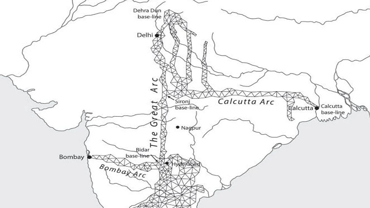
Around the year 1800, three large and distinct surveys were started concurrently in India: Revenue, Topographical and Trigonometrical. In 1878, they were finally amalgamated into one entity known as the Survey of India. It remains a thriving organization today with its headquarters at Dehra Dun (today Dehradun), roughly 125 miles north-east of New Delhi. In addition to these three major surveys, others were being undertaken as the need arose, such as the geological, archaeological and marine surveys of India.
Of the large surveys, the first and in many ways the most important, both for the ruler and the ruled, was the Revenue Survey. It was the foundation on which the entire fiscal administration of British India rested. Its prime objective was to raise revenue for the Company by taxing landholders, after having fairly assessed the productive value of their cultivable lands. This work was done out in the plantations and rice fields by small groups of workers supervised by a British officer. Each team was typically headed by a surveyor, sometimes referred to as a ‘chain-man’, many of whom were still young boys trained at the native surveying school.
In December 1799, Lambton put forward his big proposal for a ‘Plan of a Mathematical and Geographical Survey’ of the Indian peninsula by ‘ascertaining the great geographical features of a country upon correct mathematical principles’. It would accurately determine the position of all its principal points, and measure the peninsula’s precise width. What Lambton was asking for essentially amounted to a large-scale trigonometrical survey, with the hope that in time his network of triangles could be extended ‘to an almost unlimited extent in every other direction’. And a web of this nature would allow the details of any district or region to be readily filled in afterwards through topographical surveying.
The results of such a survey would be of lasting and practical benefit, and his superiors had little difficulty in appreciating this fact. What Lambton didn’t dwell on when discussing his proposal, due to its inherent complexity and scientific aspect, was another expected outcome that he quietly yet passionately desired: to determine the actual shape of the earth in this part of the world (rather than approximate it as a sphere, as is generally done)…
This extract from Mapping the Great Game – Explorers, Spies and Maps in Nineteenth-century Asia has been reproduced with permission from Penguin, the publishers.
Join our official telegram channel (@nationalherald) and stay updated with the latest headlines