Cold wave conditions to continue in northern plains, low pressure stops rain in the South
The cold wave conditions in northwest India and the northern plains have abated in general. In isolated pockets of Central India, the cold wave conditions are likely to continue for the next 2-3 days


The cold wave conditions in northwest India and the northern plains have abated in general. In isolated pockets of Central India, the cold wave conditions are likely to continue for the next two to three days.
The change in wind pattern has caused the northeast monsoon rains to stop, especially in parts of Tamil Nadu, Puducherry, Kerala and adjoining parts of Andhra Pradesh and Karnataka. This change began on Wednesday, January 2.
According to the India Meteorological Department, Ministry of Earth Sciences, a low pressure system will cause squally winds and rough seas in the Andaman Sea and neighbouring areas over the next few days.
Predicted temperature for 2019
Officials state that 2019 might be warmer than 2018. The year 2018 may have ended on a chilly note, but 2019 is expected to be warmer, senior officials said, citing El Nino and the overall trend of rise in temperatures.
According to the World Meteorological Organisation (WMO), the chance of a full-fledged El Nino being established between December 2018-February 2019 is estimated to be about 75-80%.
El Nino is a phenomenon associated with the warming of the Pacific waters and it is largely believed to have an impact on the subcontinent's weather. The weather community is divided over the extent of its impact on the monsoon.
Ministry of Earth Sciences Secretary M Rajeevan said as the year commences, the chill that covered large parts of the country is likely to dissipate.
"The temperature is likely to be above normal. El Nino is one factor while the global warming is another. We have been witnessing above normal temperatures every day," he said.
Since 2015, every passing year has clocked high temperatures. From 2015-2017, all years were recorded to be hottest.
"In an El Nino year, summers and winters witness above normal temperatures," Additional Director General of India Meteorological Department Mritunjay Mohapatra said.
Mohapatra said it is too early to predict whether El Nino would have an impact on monsoon and how would the rainy season be. Rajevaan also noted that it would be premature to say whether the El Nino would have an impact.
"El Nino is likely to end by April-May. So, it is unlikely to have an impact on the monsoon. But it is too early to predict that," Rajeevan said.
Mohapatra also pointed out to the growing erratic weather patterns, be it uneven monsoon, lethal thunderstorms that form in less than an hour, heat waves.
He said that in 2018, there were seven cyclonic storms in the Arabian Sea and the Bay of Bengal, of which four touched the mainland India.
They were Daye (September 19-22), Titli (October 8-13), Gaja (November 10-19), Phethai (December 13-18). The last time such phenomenon was observed in 1985, he said.
Although temperatures were soaring across the country, the number of heatwaves in 2018 were less in comparison to the previous year.
On the other hand, over 300 people died due to the thunderstorms, resulting in violent winds, lightening over the north Indian plains before the monsoon.
In 2018, both the southwest and the northeast monsoon were recorded as below normal. Several parts of the country have been witnessing agricultural distress due to erratic weather patterns.
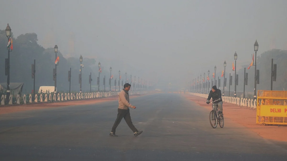
Delhi and NCR
Amid chill in the air, mercury rose by a few notches on Wednesday as the minimum temperature settled at 6.5 degrees Celsius in Delhi.
The city saw a low of 4 degrees Celsius on Tuesday even as the sun shone bright on New Year's Day, allowing revellers to come out and celebrate.
The humidity in the morning oscillated between 56 and 86%.
According to the MeT Department, the minimum temperature was recorded at 6 degrees Celsius, a notch below the season's average.
The weatherman has forecast moderate fog in the next 24 hours.
The maximum temperature in the evening is likely to hover around 23 degrees Celsius.
"The maximum and minimum temperatures on Thursday are likely to be around 23 and 5 degrees Celsius, respectively," the weatherman said.
On Tuesday, the maximum temperature was recorded at 23 degrees Celsius.
Kashmir
Kashmir received its first snowfall of the New Year on Wednesday, breaking a month-long dry spell in the Valley, the meteorological department said.
The 300-kilometre-long Jammu-Srinagar national highway and the Mughal Road, which connects Jammu's Poonch and Rajouri districts with south Kashmir's Shopian, have been closed for vehicular traffic after the fresh snowfall, officials said.
"There was snowfall at most places in Kashmir, particularly in Gulmarg and Pahalgam tourist resorts, traces of snowfall was also witnessed in Srinagar early in the morning" an official said.
Jawahar tunnel and other areas are still having snowfall. As a precautionary measure all Kashmir-bound vehicles have been stopped at Nagrota and Udhampur, the officials said.
Over 300 vehicles are stranded at various places and agencies have been deployed to clear the snow, the officials added.
The snowfall has brought major respite to the residents of Kashmir as the minimum temperature rose by several degrees, except in Gulmarg. Srinagar recorded a 0 degrees Celsius on Tuesday night -- an increase of over four degrees from minus 4.2 degrees Celsius on the previous night, the Met department said.
Gulmarg received snowfall equivalent to 8.8 mm of rains till 8.30 am, while Kupwara recorded 7.4 mm precipitation. The remaining weather stations recorded downpour between 1.5-2.5 mm during the corresponding period, the official said.
Kargil was the coldest place in Jammu and Kashmir at minus 17.0 degrees Celsius. The night temperature in Leh town in Ladakh region was minus 12.4 degrees Celsius.
On Tuesday night, Qazigund in south Kashmir recorded a low of minus 0.3 degrees Celsius, Kokernag town minus 1.4 degrees, Kupwara 0.2 degrees, Pahalgam minus 0.5 degrees and Gulmarg at minus 5.0 degrees Celsius, the official said.
Kashmir is currently under the grip of 'Chillai-Kalan', the 40-day harshest period of winter when the chances of snowfall are most frequent and maximum and the temperature drops considerably. The period ends on January 31, The weather department has predicted more precipitation in Kashmir over the next three days.
Cold Wave conditions occurred at isolated pockets over Punjab, Madhya Pradesh, Maharashtra, East Madhya Pradesh, Chhattisgarh, Telangana, North Interior Karnataka and Vidarbha. Ground frost occurred at isolated pockets of East Madhya Pradesh.
Rajasthan
Night temperature increased in several parts of Rajasthan. There was some respite for people in Rajasthan from intense cold as night temperatures increased by a few degrees, an official at the MeT Department said on Wednesday.
The night temperature in Bhilwara settled at 3.9 degrees Celsius followed by 4.4 degrees Celsius in Mount Abu.
Alwar, Churu and Chittorgarh recorded a minimum temperature of 5.4 degrees Celsius each, the official said.
Dabok, Sikar, Pilani, Jaipur, Kota and Barmer recorded minimum temperatures of 6, 6.5, 7.1, 7.9, 8.8 and 11 degrees Celsius, respectively.
Punjab and Haryana
Minimum temperatures across Punjab and Haryana also registered a slight increase on Wednesday, bringing some relief to people from cold wave conditions.
For nearly three weeks, the minimum temperatures had been hovering below the normal limits and settling between 1 and 6 degrees Celsius, with Adampur registering sub-zero temperatures on two occasions.
But, on Wednesday temperatures at several places in the two states was between 7 to 9 degrees Celsius. Meteorological (Met) department officials here said night temperatures in the region had risen due to a western disturbance, which gave rise to cloud cover.
On Wednesday, Chandigarh recorded a minimum temperature of 9.4 degrees Celsius, four notches above the normal.
In Punjab, Ludhiana recorded a low of 7.8 degrees Celsius, up by two degrees against normal while Patiala's low settled at 8.1 degrees Celsius, up three notches.
Though Amritsar recorded a low of 3.6 degrees Celsius, it was a notch above normal.
Adampur recorded a low of 8.1 degrees Celsius, Halwara's minimum settled at 6.1 degrees Celsius while Bathinda registered a minimum of 8.5 degrees Celsius. Pathankot recorded a low of 8.8 degrees Celsius.
In Haryana, Ambala registered a low of 8.5 degrees Celsius, up by two degrees against the normal while Bhiwani's minimum settled at 7.8 degrees Celsius.
Hisar recorded a low of 7.5 degrees Celsius, up one notch while Sirsa and Rohtak, too, recorded above normal minimums at 9.1 degrees Celsius and 9 degrees Celsius, respectively.
The Met officials said fog reduced visibility this morning at several places including Hisar, Bhiwani, Amritsar, Ludhiana and Patiala.
South India
In the southern regions the weather has been mostly pleasant.
In parts of Telangana and North interior Karnataka there was a cold spell that is predicted to last over the next few days.
Dry weather prevailed over Kerala, Lakshadweep, Andhra Pradesh, Telangana and Karnataka.
(with inputs from PTI and IANS)
Join our official telegram channel (@nationalherald) and stay updated with the latest headlines