Survey of India not making maps of J&K freely available
People continue to download unauthorised maps of Jammu and Kashmir from the internet in the absence of authorised maps being made freely available by the Survey of India


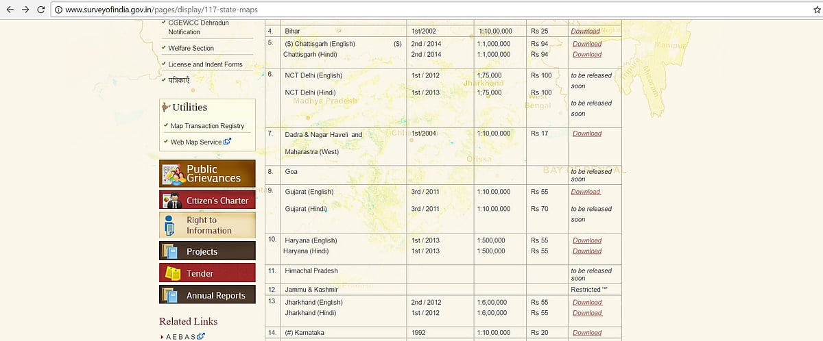
One reason why unauthorised maps of Jammu and Kashmir (J&K) continue to get published is because the Survey of India has restricted access to the maps. While the Survey of India sells maps of all other states on nominal charges, its website restricts access to the maps of Jammu and Kashmir.
And, although RSS-affiliated Rashtriya Mukti Morcha had also invited controversy by putting up a ‘faulty’ map of the state in a hoarding at its Relief Road office in Ahmedabad, publication of an unauthorised map of Jammu and Kashmir in a booklet published by the Congress over the weekend made several BJP leaders see red.
“Is it for this that hundreds of our brave soldiers have given up their lives over the years defending our sovereignty and territorial integrity?” said Union Minister Venkaiah Naidu in Hyderabad and asked if the final solution that the Congress had in mind was to give Kashmir to Pakistan, referring to the map which showed the state as ‘Indian occupied Kashmir’.
A quick check reveals that besides the RSS and the Congress, media houses, text book publishers, NGOs, international publications as well as individuals have been guilty of the ‘offence’ which now invites imprisonment up to seven years and a fine of up to ₹100 crore.
Ironically , while Congress leader Ghulam Nabi Azad found himself caught on the wrong foot over the week-end, Azad himself had cornered the government in the Rajya Sabha on the wrong map of Jammu and Kashmir that was published by the RSS mouthpiece Organiser in March 2015.
But, while people continue to download maps of Jammu and Kashmir from the Internet, in the ‘map and data’ section of its website, Survey of India, the national survey and mapping organisation of the country under the Department of Science and Technology, has restricted access to the maps of Jammu and Kashmir.
While it has put up price of hard copies of many state maps besides giving free access to view and even download these maps, it has placed Jammu and Kashmir in the restricted category.
RM Ghildiyal, section-in-charge of Map Archive and Dissemination Centre, Dehradun, said: “It’s restricted because the map is not final. It has LoC (Line of Control) and then Ladakh borders China.”
Even though Arunachal Pradesh too has a border dispute with China, he feigned ignorance as to why its state map was available for free download on Survey of India’s website. “We deal with hard copies only. Soft copies are looked after by Surveyor General of India. Usually, state maps are made available by the geo-spatial data centres of the state concerned,” he added.
Some of the major controversies involving disputed maps of Jammu and Kashmir in recent years are the following:
- In 2011, The Economist magazine showed a disputed map of Kashmir that led its copies to being seized and censored by India.
- In 2014, the Urban Development Department of Bihar suspended an employee and served a show-cause notice on an engineer in connection with a row over a map of India on its website showing Jammu and Kashmir and Arunachal Pradesh outside the country.
- In April 2015, Indian government took Al Jazeera news channel off the air for five days after officials insisted it had repeatedly shown wrong maps of Kashmir in past.
- In 2015, a map of India showing a large area of Kashmir as part of Pakistan in a Bangladesh Tourism brochure led to BJP’s Yuva Morcha protest outside the Bangladesh stall at the Calcutta Book Fair.
- In 2012, a controversy erupted when a map named Pakistan-administered-Kashmir as “Azad Kashmir” and Gilgit-Baltistan as “Northern areas” in an exercise book prescribed for Class III by the Central Board of Secondary Education (CBSE).
- Principal and owner of a school in Shahdol district of Madhya Pradesh was arrested along with three others on charges of sedition in July 2016. The school’s diary was allegedly found to have carried a map of India that excluded parts of Jammu and Kashmir.
Join our official telegram channel (@nationalherald) and stay updated with the latest headlines