Escalation in Ladakh: India and China beef up troop strength at high altitude
Indian Army is understood to have flown in troops from other high altitude areas to Eastern Ladakh. This followed Intelligence inputs that Chinese brought in its troops engaged in exercise in Tibet<b></b>


Ten years ago, an Indian Army helicopter had flown over the ‘saddle’ once and then flew back. It landed in Daulat Beg Oldi (DBO), its rotors blowing clouds of brown dust in the last major military outpost in Sub Sector North (SSN), 18 kms short of the Karakoram Pass in India’s Eastern Ladakh.
“Those guys have put up a pole with cameras looking at us”, the Army officer who was just taken on an aerial recce told the local commander on disembarking. He was referring to Chinese cameras looking into India.
“Fair enough,” he said. “Let’s do the same”.
Almost overnight the Indian Army put up not one, but six poles with cameras looking into China.
The Karakoram Pass at 18,176 feet has the feature of a ‘saddle’ on a ridgeline. It marks the India-China border.
Though none of the armies of the two countries physically hold it, they patrol the pass. At one point, Indian and Chinese cameras, each mounted on poles, were just about five metres apart.
The Pass itself is not disputed. Technically, it is not in Aksai Chin, Tibet, 38000 sq kms of which India claims. It forms the boundary with the Chinese province of Xinjiang. But India cannot afford to under-assess its strategic value.
Access to the Pass through patrols, and now, remotely piloted aerial vehicles with surveillance cameras, are indispensible methods of monitoring it for the Indian Army.
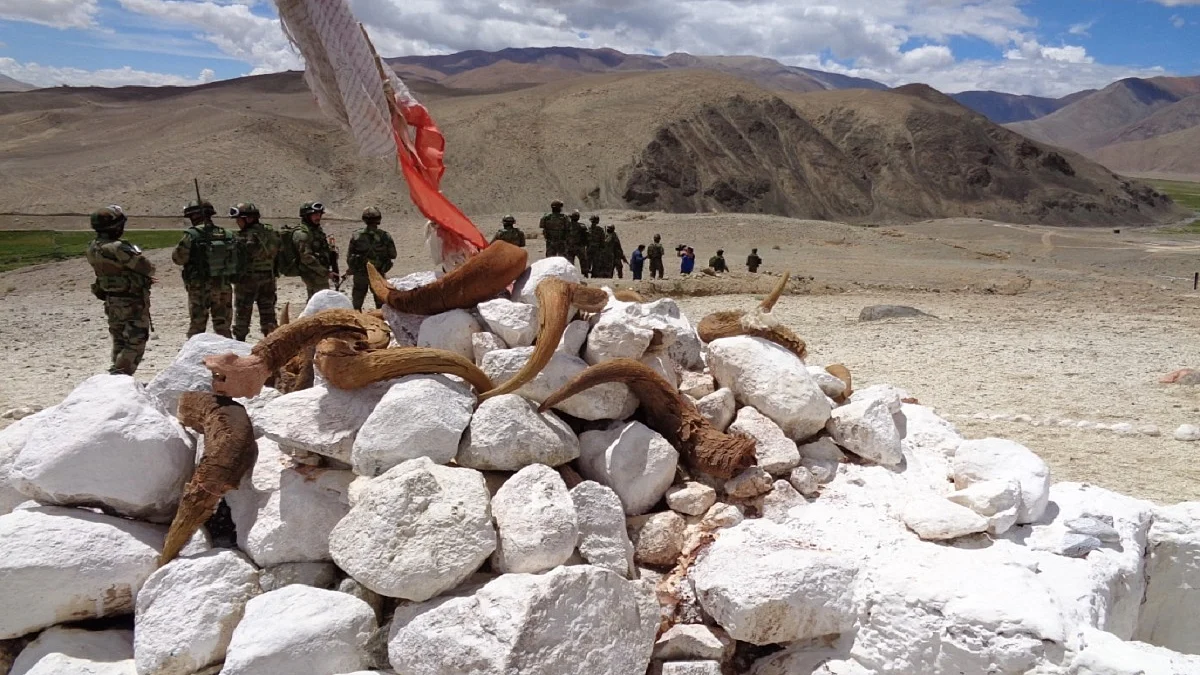
Face-offs that are temporary, lasting from a few minutes to or even up to a week, are par for the course in Eastern Ladakh.
It is already, however, more than 20 days this time with the risk of escalation increasing by the day. The fisticuffs in August 2019 and again on May 5-6 this year and on May 9 at Naku La in North Sikkim have underscored how delicate a tenuous peace on an unmarked frontier can be.
Conventionally, Indian and Chinese commanders host ceremonial meetings on either’s national days at Daulat Beg Oldi and at the Spanggur Gap in Chushul Valley. This year, the Chinese did not call on May 1, International Workers’ Day that the Chinese Communist Party observes. They also did not pick up calls from the Indian side but later conveyed that it was because of the pandemic.
The Border Personnel Meeting (BPM) point at the Spanggur Gap on the Indian side is a large conference room with posters from Amitabh Bachchan and Rajesh Khanna and Aamir Khan and Dimple Kapadia-starrers. It is large enough for “socially distanced” meetings.
But on May Day this year there was only the echo of silence and the whistling of a cold desert wind in mid-summer.
On Monday, May 25 former foreign secretary and envoy to China Nirupama Menon Rao tweeted, “Given absence of line of separation and mutual distancing between sides, no jointly highlighted areas of difference of perception of LAC, we r bound to see more such incidents which now, additionally, have potential to turn into armed confrontation and conflict.”
If reports of troops being flown in turn out to be true, her apprehension of an armed conflict cannot be dismissed lightly.
In each of the areas where Chinese troops are facing Indian troops – or, in the words of the Indian ministry of external affairs – where the Chinese have stopped Indian patrols – India had taken a beating in the 1962 war. An ill thought out policy had led to the establishment of weakly-defended forward posts by Indians without the wherewithal to support them. The Indian posts were overrun.
But in 2006, under Prime Minister Manmohan Singh, India changed its policy on border roads. Till then, the belief was that if the roads were metalled, they would ensure easier mobility to the Chinese in the event of hostilities. That policy was reversed and the Border Roads Organisation (BRO) was asked to upgrade 73 roads on the Himalayan frontier.
That policy has continued under the Modi Administration. The order of battle (ORBAT) in Eastern Ladakh, too, has been re-organised with the creation of “loop” battalions – units of soldiers that were either returning from or on their way to the highest posts. This ensured that there was always a reserve line of troops in the barren heights where the air is rare (with scant oxygen) and troops have to be acclimatized.
The face-offs happen, for sure, because of the “differing perceptions of the Line of Actual Control (LAC), as successive governments have claimed. India claims all of Aksai Chin, all 38,000 sqkms of it, and it regards any Chinese military presence in the area, controlled from Tibet’s Nyari prefecture, as illegal.
But on the ground, the Indian and Chinese armies have “patrolling limits” that determine the line. For India, the limits are set by the China Study Group (CSG), a committee within the government comprising political, diplomatic, bureaucratic and military leaders.
One such patrolling limit for the Indian Army foot and water-borne patrols on the Pangong Tso is “Finger 8”. The spurs of the Chang Chenmo roll down to the North Bank of the lake and are shaped like upturned fingers of the human hand. The fingers are numbered from the northwest, the portion of the 140-km boomerang-shaped lake that India holds, from a place called Lukung.
But they are observed also from the South Bank, from, among others, a high-point called Thakung.
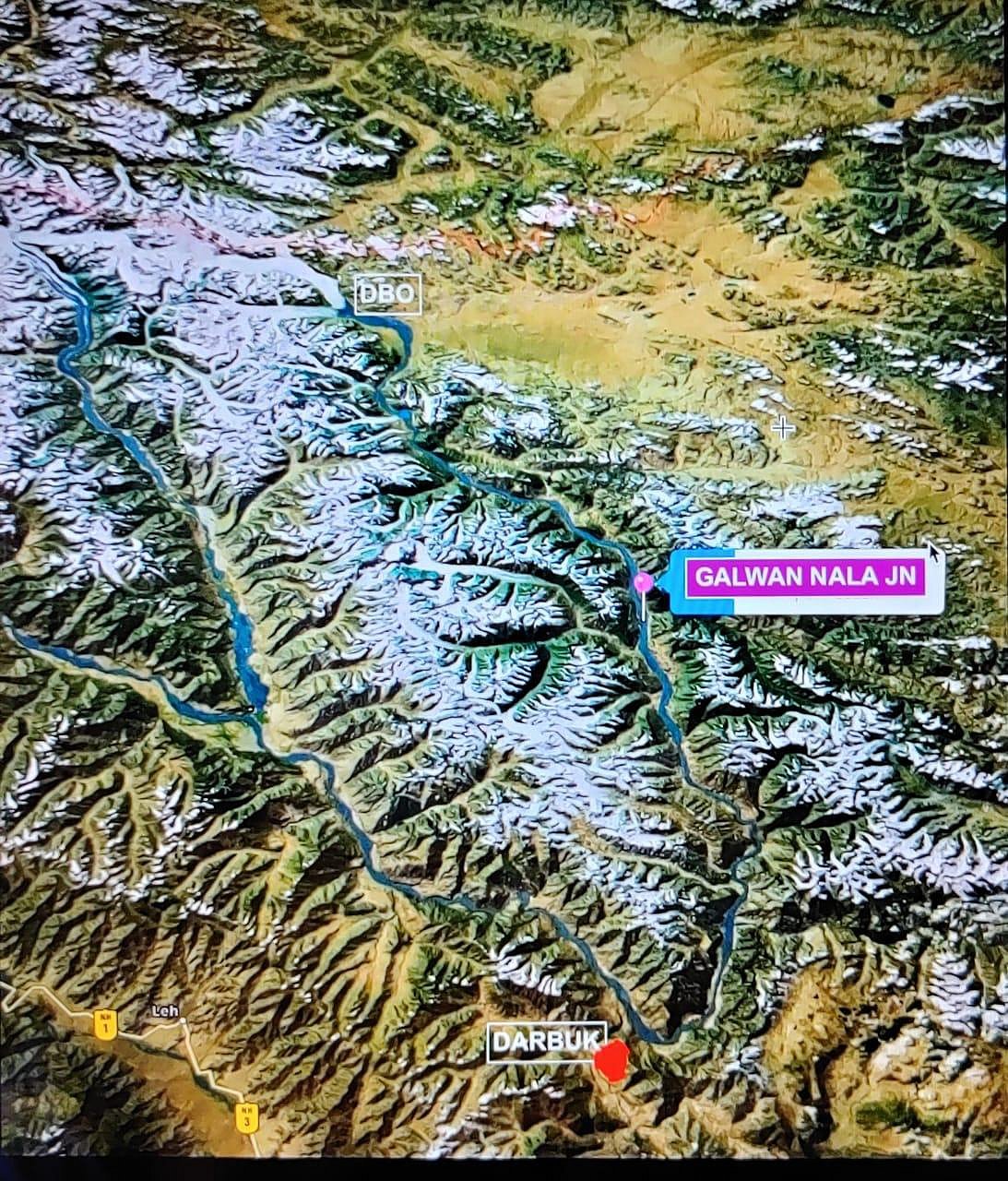
India’s patrols to Finger 8 have now been stopped by the Chinese at Finger 2. To access Finger 8, therefore, Indian troops have tried an alternate route from behind the Chang Chenmo range, looking west to east more than a 100 kms south east of the Galwan confluence with the Shyok.
It is the access to the look-out point at Karakoram Pass that is threatened by the current military stand-off between Indian and Chinese troops at three points – the Galwan Valley, the ‘Fingers’ on the North Bank of the Pangong Tso, the picturesque lake, and just behind and across the Chang Chenmo Range to the east in the Hot Springs.
Depending from where you are looking, the total frontage of the stand-offs is about 20 kilometres. In at least one point, it is about three kilometres deep inside Indian territory from the Indian Army’s ‘patrolling limit’.
There is, theoretically, aerial access to Daulat Beg Oldi, where the Indian Air Force re-activated an Advanced Landing Ground (ALG) in 2008. But even for the special operations-equipped Hercules C-130J airlifters, the ALG has to be readied. Also, it is observable from Chinese positions.
The access to Daulat Beg Oldi is along the 255 kms Darbuk-Shyok-DBO (DSDBO) road, rebuilding of which began in 2001. The Galwan Valley is closest to the DSDBO road from the east, from a point where a Rs 72 crore bridge on the Shyok River was opened last year.
The Shyok is a wild river. Its banks are wide, but its waters flow wild, depending on the season and the glaciers that melt into it. It is in spate usually from August when its tributaries trigger mudslides and rockfalls. Indian military traffic to and from DBO therefore has to choose alignments depending on the course of the water.
The Indian axis to DBO from Darbuk is vulnerable to Chinese interdiction on the ground in many areas, particularly between points 135 and 148 (kilometres). North of Galwan is another nullah that flows into the Depsang Plains, the Raki Nullah, where the Indian and Chinese militaries faced-off in a loudspeaker-cum-tent war in 2013 before it was diplomatically resolved.
South of Darbuk, the road or paved track extends all along the South Bank of the Pangong Tso, through the Chushul Valley, onto the Dungti Gap and Nyoma. Further to the South and East it goes to Demchok and Chumur skirting the Tso Moriri. The total length of the border in Eastern Ladakh – not what Indian school text books depict but what it is on the ground – is about 886 kms from north to south.
Given the nature of the terrain, the ability to see far from heights and the ability to interdict traffic on this main axis determines military superiority for the Indians and the Chinese in Eastern Ladakh.
While the areas of the SSN, the Chushul Valley and Demchok-Chumur are along one continguous stretch, the physical features are a combination of high, serried, barren mountains, flat high-altitude valleys and brackish water lakes. The two most important rivers are the Shyok and the Indus. There is an Upper Shyok Valley – where the waters flow north to south in the SSN – and a Lower Shyok Valley where the waters flow south to north below Darbuk after a U turn.
The General who has seen it all: In some ways however, India’s China policy in recent years has a reflection in the military career of the current General Officer Commanding-in-Chief, Northern Command, Lt General Yogesh K Joshi. A hero of the Kargil war with Pakistan in 1999, Joshi went on to serve as defence attaché in Beijing after commanding a brigade near Bumla in Arunachal, also facing China.
As the defence attaché, General Joshi was the linchpin of the first India-China military wargames, Exercise Hand-in-Hand at Kunming in 2007. Subsequently, the General went on to command the 14 Corps headquartered in Leh that is directly responsible for the defence of Ladakh, Siachen Glacier and the Kargil heights.
Few can claim to have the depth of expertise and experience that Lt General Joshi brings into the northern command.
He has seen through cameras looking in and looking out.
( Sujan Dutta is an independent journalist based in Delhi )
Join our official telegram channel (@nationalherald) and stay updated with the latest headlines