Cyclone Remal to make landfall on Sunday night, red alert in WB
IMD warns of extremely heavy rainfall in the coastal districts of West Bengal and northern Odisha


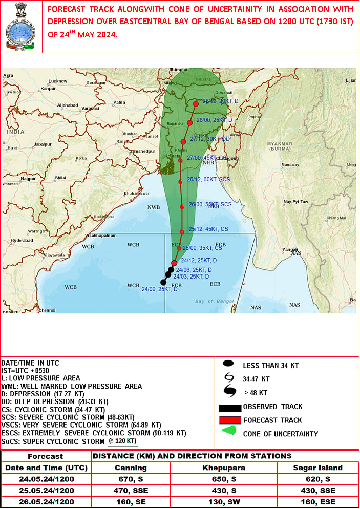
A depression in the Bay of Bengal is likely to concentrate into a severe cyclonic storm and make landfall along the adjoining coasts of West Bengal and Bangladesh around 26 May midnight, bringing heavy rain in the coastal districts of the state and in north Odisha, the Indian Meteorological Department (IMD) said on Friday.
This is the first cyclone in the Bay of Bengal this pre-monsoon season and will be called Remal, a name given by Oman, according to a system of naming cyclones in the north Indian Ocean region.
The system is likely to intensify into a severe cyclonic storm and make landfall between Sagar Island in West Bengal and Khepupara in Bangladesh, the IMD said in a bulletin.
The cyclone could reach a wind speed of 120 kmph on Sunday, and IMD has warned of extremely heavy rainfall in the coastal districts of West Bengal and north Odisha on 26-27 May. Extremely heavy precipitation may hit parts of northeast India on 27-28 May.
A storm surge of up to 1.5 m is expected to inundate low-lying areas of coastal West Bengal and Bangladesh at the time of landfall. The weather office has warned fishermen not to venture into the sea in north Bay of Bengal until the morning of 27 May, and IMD has issued a red alert for West Bengal's coastal districts of South and North 24 Parganas on 26 and 27 May.
It has warned of 100 to 110 kmph wind speed gusting to 120 kmph in South 24 Parganas and 90 to 100 kmph gusting to 110 kmph in North 24 Parganas on 26-27 May, accompanied by extremely heavy rainfall at one or two places on both days.
An orange alert was issued for Kolkata, Howrah, Nadia and Purba Medinipur districts by IMD, warning of 80 to 90 kmph gusting to 100 kmph wind speed, accompanied by heavy to very heavy rain at one or two places on the two days.
The depression, which lies over the central Bay of Bengal, about 660 km south-southeast of Sagar island, is likely to concentrate into a cyclonic storm by 25 May morning, IMD said.
The weather office forecast heavy rain in Purba Medinipur district on 25 May, on which date elections are scheduled to be held in Tamluk and Kanthi (Contai) Lok Sabha constituencies in the coastal district.
Moving in a northward direction, the system will further concentrate into a severe cyclonic storm by 25 May evening and cross the coast between Sagar Island and Khepupara around midnight of 26 May, the weather office said.
Wind speed will reach 60 to 70 kmph gusting to 80 kmph over Hooghly, Purba Bardhaman and Paschim Medinipur districts, accompanied by heavy rain. The remaining districts in south Bengal will experience wind speed of 40 to 50 kmph gusting to 60 kmph, it said.
In north Odisha, the coastal districts of Balasore, Bhadrak and Kendrapara will receive heavy rain on 26-27 May, while precipitation is likely in Mayurbhanj on 27 May.
The IMD warned of localised flooding and major damage to vulnerable structures, power and communication lines, kutcha roads, crops and orchards in South and North 24 Parganas districts of West Bengal. Residents in affected areas have been asked to remain indoors and vacate vulnerable structures.
Scientists say cyclonic storms are intensifying rapidly and retaining their potency for longer periods owing to warmer sea surface temperatures, a result of oceans absorbing most of the excess heat from greenhouse gas emissions. The past 30 years have witnessed the highest sea surface temperatures since records started being maintained in 1880.
According to senior IMD scientist D.S. Pai, warmer sea surface temperatures mean more moisture, which is favourable for the intensification of cyclones. Madhavan Rajeevan, former secretary of the Union ministry of earth sciences, said a sea surface temperature of 27ºC and above is needed for a low-pressure system to intensify into a cyclone.
The sea surface temperature in the Bay of Bengal is around 30ºC at present. "The Bay of Bengal and the Arabian Sea are very warm at present, so a tropical cyclone can easily form," Rajeevan said.
But tropical cyclones are not only controlled by the ocean, the atmosphere also plays an important role, especially in terms of vertical wind shear — a change in wind speed and/or wind direction with altitude. "A cyclone will not intensify if the vertical wind shear is very large. It will weaken," Rajeevan said.
Join our official telegram channel (@nationalherald) and stay updated with the latest headlines