Nation
North India hit by rain and snow, on orange alert as temperatures dip
From 8 October onwards, cold northwesterly winds are expected to cause a further dip in the mercury across northwestern states
A major weather shift has swept across large parts of northern India, bringing fresh snowfall in the upper reaches and widespread rainfall in the plains, leading to a significant drop in temperatures and a palpable shift to winter-like conditions.
The India Meteorological Department (IMD) has issued orange alerts for several regions, warning of heavy rain, thunderstorms, hail, and gusty winds in the days ahead.
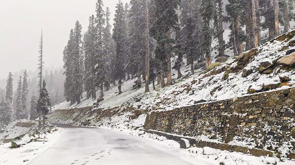
In the Kashmir Valley, fresh snowfall was reported in the higher altitudes on Monday, including Sinthan Top in Anantnag, Affarwat in Gulmarg, Zojila Pass, Razdan Pass in the Gurez Valley, and Bangus in Kupwara.
These developments were accompanied by light to moderate rainfall in the plains, including Srinagar city.
The sudden change in weather caused daytime temperatures to plunge nearly 10ºC. Srinagar, which recorded 22.6°C the previous day, saw the maximum drop to around 11°C on Monday, 6 October. Officials have forecast continued wet weather across the region over the next 24 hours.
Neighbouring Himachal Pradesh experienced the season’s first snowfall on Sunday morning, with Rohtang Pass and the Dhauladhar range blanketed in white.
The snow and subsequent rainfall triggered a sharp decline in temperatures, prompting the Kullu district administration to suspend vehicular movement to Rohtang Pass and advise against travel along the route.
Mild snowfall was also observed on the Dhauladhar range, while several districts, including Kangra and Chamba, received overnight rain, pushing mercury levels down and introducing early winter-like conditions.
Hill towns like Dharamsala, McLeodganj, Palampur, Dalhousie, Chamba, and Bharmour witnessed a marked change in weather, with chilly winds replacing the unseasonal warmth of recent days. Intermittent rainfall through Monday morning brought dense fog to upper mountain regions.
Reports of thunderstorms, lightning, and strong winds ranging from 30 to 61 kmph came from areas such as Kufri, Jot, Sundernagar, Bhunter, Kangra, Shimla, and even lower hills like Bilaspur and Hamirpur. Several incidents of uprooted trees due to heavy downpour and wind were also reported.
Rainfall readings released by the Met Department showed Dharamsala recording 25.5 mm of rain overnight, while Brahmani logged 26.4 mm, followed by Nangal Dam with 23 mm, Malraon with 22 mm, and Bilaspur with 20.4 mm.
Minimum temperatures across the state dropped by 1–3°C. Tabo recorded the coldest temperature at 3.1°C, followed by Keylong at 3.6°C, and Kalpa and Kukumseri at 6.2°C. Kufri and Narkanda recorded lows of 10°C. An orange alert has been issued for 6 October in six districts — Chamba, Kangra, Kullu, Mandi, Sirmaur, and Lahaul-Spiti — warning of heavy to very heavy rain, hailstorms, thunderstorms, and winds of up to 50 kmph.
Delhi faces heavy rains
Meanwhile, Delhi and the National Capital Region (NCR) also experienced heavy rainfall late on Sunday night and into Monday afternoon, bringing long-awaited relief from persistent heat and humidity. The IMD issued an orange alert for Delhi, Noida, and Ghaziabad, while Gurugram and Faridabad remained under a yellow alert. Delhi’s Safdarjung observatory recorded 10.3 mm of rainfall by 8:30 am, with Lodhi Road receiving 13.2 mm, Palam 4.6 mm, Ridge 8.2 mm, and Ayanagar 5.4 mm.
The rains brought down the minimum temperature in Delhi to 20.6°C, two degrees below normal. Sunday’s maximum temperature had reached 34.1°C, but was expected to settle around 29°C on Monday due to the cloud cover and rain.
The forecast includes continued light to moderate rainfall, accompanied by thunderstorms, lightning, and gusty winds of 30–40 kmph through the evening.
The ongoing weather activity across northern India has been triggered by a western disturbance that began impacting the region from Monday. The IMD predicts that its influence will continue through 7 October, with further deterioration in weather conditions expected in Jammu and Kashmir, Himachal Pradesh, Punjab, Haryana, Chandigarh, Delhi, Uttarakhand, western Uttar Pradesh, and Rajasthan.
In addition to heavy rainfall, isolated hailstorms are likely in several of these areas, particularly in Himachal Pradesh, Jammu and Kashmir, Punjab, Haryana, western UP, and parts of Rajasthan.
From 8 October onwards, cold northwesterly winds are expected to cause a further dip in minimum temperatures across the northwestern states, with forecasts indicating a drop of 4-5ºC over the following two days.
Authorities have advised caution and preparedness, especially in vulnerable and high-altitude regions.
With agency inputs
Join our official telegram channel (@nationalherald) and stay updated with the latest headlines