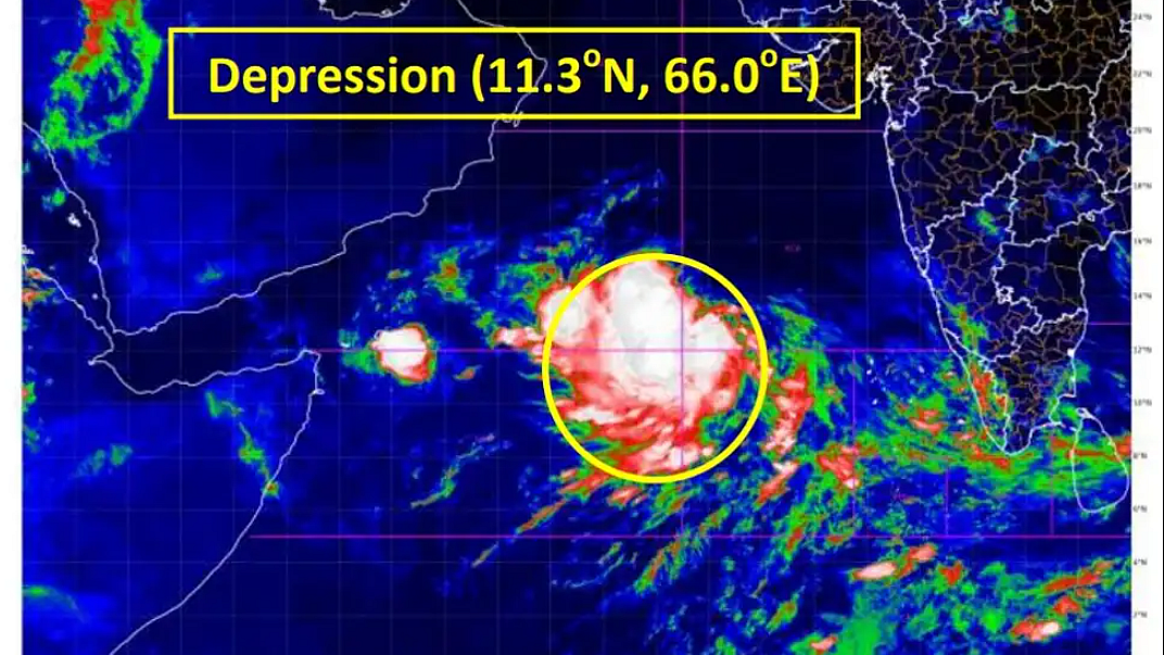
Cyclone Biparjoy rapidly intensifies into severe cyclonic storm
The IMD had on Tuesday said the cyclone is likely to influence the monsoon progress

Cyclone 'Biparjoy' has rapidly intensified into a severe cyclonic storm, with meteorologists predicting a "mild" monsoon onset over Kerala and "weak" progress beyond southern peninsula under its influence.
Cyclone 'Biparjoy' is the first storm brewing in the Arabian Sea this year.
In an update, the India Meteorological Department (IMD) said, "Cyclonic storm Biparjoy over east-central and adjoining southeast Arabian Sea moved nearly northwards with a speed of 2 kmph during the last six hours, intensified into a severe cyclonic storm and lay centred over the same region at 0530 hours, about 890 km west-southwest of Goa, 1,000 km southwest of Mumbai, 1,070 km south-southwest of Porbandar and 1,370 km south of Karachi".
The Met office said it is likely to move nearly northwards and intensify into a very severe cyclonic storm. It would then move north-northwestwards during the subsequent three days.
However, the IMD has not yet predicted any major impact on countries adjoining the Arabian Sea, including India, Oman, Iran and Pakistan.
Meteorologists say the tentative track of the system will be in the northward direction but storms at times defy the predicted track and intensity. Forecasting agencies said the storm has been undergoing "rapid intensification".
Cyclone Biparjoy intensified by 40 knots (74 kmph) since Tuesday morning, according to the Joint Typhoon Warning Centre (JTWC), the US Department of Defense's agency responsible for issuing tropical cyclone warnings for the Pacific and Indian Oceans.
Scientists say cyclonic storms in the Bay of Bengal and the Arabian Sea have been intensifying rapidly and retaining their intensity for a longer duration due to climate change.
According to a study 'Changing status of tropical cyclones over the north Indian Ocean', the Arabian Sea saw a significant increasing trend in the intensity, frequency, and duration of cyclonic storms and very severe cyclonic storms during the 1982-2019 period.
"The increase in cyclone activity in the Arabian Sea is tightly linked to the rising ocean temperatures and increased availability of moisture under global warming. The Arabian Sea used to be cool, but now it is a warm pool," said Roxy Mathew Koll, Climate Scientist at the Indian Institute of Tropical Meteorology.
The IMD had on Tuesday said the cyclone is likely to influence the monsoon progress.
A senior IMD scientist said the southern peninsula will get rain under the influence of the cyclonic storm and a low-pressure system developing in the Bay of Bengal. However, further progress of the monsoon beyond the southern peninsula will happen after the cyclone degenerates.
"The cloud mass is concentrated around this system and enough moisture is not reaching the Kerala coast. Though the criteria for monsoon onset can be met in the next two days, it will not be a thumping start," Mahesh Palawat, vice president (climate and meteorology), Skymet Weather, said. After the onset over Kerala, the monsoon will remain "weak" until the storm degenerates around June 12, he said.
"The powerful weather system in the Arabian Sea may spoil the advancement of the monsoon deep inland. Under their influence, the monsoon stream may reach coastal parts but will struggle to penetrate beyond the Western Ghats," Skymet Weather had said on Tuesday.
The southwest monsoon normally sets in over Kerala on June 1 with a standard deviation of about seven days. In mid-May, the IMD said monsoon might arrive in Kerala by June 4.
Skymet had predicted the monsoon onset over Kerala on June 7 with an error margin of three days.
Over the last 150 years, the date of monsoon onset over Kerala has varied widely, the earliest being May 11, 1918 and the most delayed being June 18, 1972, according to IMD data.
The southeast monsoon arrived in the southern state on May 29 last year, June 3 in 2021, June 1 in 2020, June 8 in 2019 and May 29 in 2018.Research shows a delay in the monsoon onset over Kerala (MOK) does not necessarily mean a delay in the monsoon onset over northwest India.
However, a delay in the MOK is generally associated with a delay in onset at least over the southern states and Mumbai. Scientists say a delayed MOK also does not impact the total rainfall over the country during the season.
India is expected to get normal rainfall during the southwest monsoon season despite the evolving El Nino conditions, the IMD had earlier said.
Northwest India is expected to see normal to below-normal rainfall. East and northeast, central, and south peninsula are expected to receive normal rainfall at 94-106 per cent of the long-period average of 87 centimetres.
Rainfall less than 90 per cent of the long-period average is considered 'deficient', between 90 per cent and 95 per cent is 'below normal', between 105 per cent and 110 per cent is 'above normal' and more than 100 per cent is 'excess' precipitation.
Normal rainfall is critical for India's agricultural landscape, with 52 per cent of the net cultivated area relying on it. It is also crucial for the replenishing of reservoirs critical for drinking water apart from power generation across the country.
Rainfed agriculture accounts for about 40 per cent of the country's total food production, making it a crucial contributor to India's food security and economic stability.
Follow us on: Facebook, Twitter, Google News, Instagram
Join our official telegram channel (@nationalherald) and stay updated with the latest headlines
