Opinion
Let this warning not go in vain
The flood disaster of 26 August was not the first nor the last. Shekhar Pathak tells us, yet again, what we must learn from it
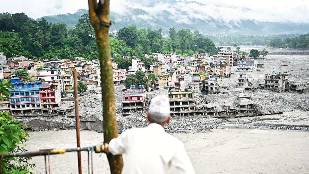
The stretch of the Himalaya along the Tibet-Nepal border where the 26 August disaster originated is exceptionally fragile. Only last year, on 8 July, a flood here killed 18 people. It destroyed the Nepal-Tibet Road, the check post at Rasuwagadhi, bridges, hydropower projects and transmission lines. There is no official account of what happened on the Tibetan side that year, though an advance warning did come from China.
This time, no such warning was possible. Perhaps no one expected such an event on a clear, rainless day. It happened so quickly that the information system could not respond in time. Yet the very next day, China informed Nepal that landslides had created two lakes on two tributaries of the Bhote Koshi, the Tushchen and Purepu, and advised Nepal to stay alert. There must also have been loss of life and great destruction of property in Tibet, though official information is still awaited.
Eleven years earlier, on 25 April 2015, Nepal was struck by a magnitude 7.8 earthquake, the country’s biggest since 1934. More than 9,000 people were killed and over 22,000 injured across Nepal, India, China and Bangladesh. It also triggered an avalanche on Mt Langtang’s south face, burying 300 people in Langtang village.
As of 7 September, 1,400 lives have been lost this time — 1,357 in Nepal and 43 in Tibet. The destruction of property — offices, schools, roads, bridges, hydropower and solar-energy projects besides homes, shops, hotels, restaurants and cottage industry units as also community assets like temples, chortens, watermills and panchayat buildings — has been enormous. Nepal’s finance minister has estimated the losses at $4-5 billion.
More than 1,600 people from 32 countries, including 300 Indians, were reportedly still missing at the time of writing — over a thousand in Nepal and about 600 in Tibet. Human bodies were later seen floating in the Gandak in India.
These numbers will inevitably swell as more information comes in. Most of those killed or uprooted were farmers, livestock-rearers and owners of small businesses. There were also many pilgrims and tourists in the region as thousands use this route every year to go to Kailas-Mansarovar and other pilgrimage sites. Animals and wildlife were also killed, and what happened to the fish is beyond our imagining.
The disaster would have caused less devastation had the development model in Tibet and Nepal been shaped by studies of the region’s geology, seismicity, geography and flood history. Governments refuse to learn or try to be too clever, and engineering does not adapt in step with a changing environment.
Within minutes, the flood destroyed 12 hydropower projects — eight operational, four under construction — besides 41 bridges, transmission lines, power substations, heavy machinery, bulldozers, trucks… A successful 25 MW solar project at Nuwakot was buried under debris. More than 100 km of highway was destroyed.
At the Trishuli hydropower project and in other tunnels, 917 workers, including 70 Indians, were left suspended between life and death. It is estimated that the river carried 100-200 million cubic metres of debris, mud, silt, trees, other material and machinery at a flow speed of 193 kmph!
****
Nepal must, of course, reflect on how to deal with the consequences of this disaster, what lessons to draw from it and what precautions to take in future. But what is really needed now is a broad dialogue among all Himalayan countries — Afghanistan, Pakistan, India, Nepal, Bhutan, Myanmar, Bangladesh and China.
We share mountains and rivers, and challenges too — like pollution, earthquakes, glacial lake outbursts that can generate catastrophic floods and other disasters driven by climate change, which will only increase in the future.
Nepal must open a dialogue with India and China because we share rivers, but the scope of these discussions must be the entire Himalaya. Nepal must also present its concerns forcefully at climate summits and environmental conferences, international forums and the United Nations.
The disaster also gives Nepal’s political, social, community, cultural and religious leaders an opportunity to think of developing a safer model of development for their country. The youth, in particular, must think deeply about this.
Projects designed for entirely different environments should not once again be imposed on Nepal or other Himalayan regions. Sustainable agriculture, cottage industry, pastoralism and seasonal migration should sit at the heart of the planning for pilgrimage, tourism and energy production.
The ideas of ‘Small is Beautiful’ and ‘Gross National Happiness’ (GNH) are particularly relevant to mountains and ecologically fragile regions. If not in their entirety, they should be followed as far as possible. Engineering and technology should be used to solve the problems of the mountains, not to challenge the mountains.
The Himalaya is still forming and rising. Earthquakes, landslides, avalanches, retreating glaciers, snowstorms, floods and forest fires are all part of its nature. Human beings have not achieved even partial mastery over these processes. What they can do is look for ways to protect life and property.
In a monsoon-driven ecosystem, floods have many meanings. They can alter landforms. Floods are no doubt shaped by rainfall and the hydrological cycle, but also by the condition of the watershed, the severity of rainfall, vegetation cover, slope, seismicity and groundwater levels. Manmade structures and human interventions in a river’s channel and floodplain — dams, barrages, uncontrolled mining, deforestation, weakened watersheds, encroachment on riverbanks — can make a river more aggressive. As indeed can climate change.
Communities that live by rivers watch their behaviour — the amount of water they carry, changes in colour and other signs. People traditionally avoided encroaching on the riverbed or floodplain. There was a time when small floods were awaited in the plains because they brought rich, fertile soil. In the mountains, floods create seras (the fertile flatland/s) along river valleys. Similarly, people of the high Himalaya understand the moods of glaciers and avalanches.
When we flout unwritten rules and traditions followed for generations, when greed or even necessity leads to dangerous encroachments, the community leadership must step in to remind people not to cross the ‘Lakshman rekha’. Children must be raised with this awareness; it must be woven into education.
The Hindu Kush-Himalayan region has another serious problem: only about five per cent of its land is cultivable. Most of the fertile land lies in river valleys; the rest is on terraced slopes. This is also the land held in individual ownership. Pressure on such scarce land has repeatedly led to encroachment, and people have repeatedly paid the price.
In recent decades, the encroachment on this land, on its forests and water, on the wilderness and biodiversity, has come in the name of ‘development’.
Development is necessary, but the current models violate Himalayan ecology. Modern engineering is useful in many situations, but the Himalaya needs a model that takes into account that it is a young and fragile mountain system, sitting atop a maze of geological faults vulnerable to earthquakes, landslides and avalanches.
****
Many parts of Nepal and Uttarakhand are regarded by geologists and seismologists as ‘seismic gap areas’. Seismic gaps areas are regions where no major earthquake has occurred for centuries. Geological energy remains trapped and accumulates, and one day it may produce a massive earthquake. Many of these areas lie around the Main Central Thrust, or MCT, regarded as one of the most active fault systems of the Himalaya.
Tibet and the Himalaya — or, more broadly, the Indian subcontinent — are divided into many geological, climatic, ecological and agricultural zones. Rivers behave differently in different regions. In the high Himalaya, many valleys are narrow and steep-sided. When snow and rock break loose and tumble down, they may block a river for some time. When the resulting lake bursts, it can wreak havoc downstream. By now, everyone knows this.
We also need to understand the difference between old foundational ice or permafrost and fresh snow. In the high Himalaya and mountain passes, fresh snow settles over older ice. Water searches out a channel and flows away. When rising temperatures cause rain instead of hail or snow at high elevations, the destructive power of water multiplies many times.
Recall 16-17 June 2013, when heavy rain fell in Kedarnath. Rain probably fell over Chorabari Tal as well, where a natural dam of moraine and large boulders broke. The lake was small, but the rainfall was immense (400 mm in 24 hours). Despite the relatively broad terrain around Kedarnath, a large part of the town was swept away.
The destruction was even greater at Rambara and Gaurikund, where the Mandakini runs through a narrow valley. Downstream, muck and debris from barrages and tunnels amplified the disaster. But it must be remembered that the prime driver of the devastation was roughly 400 mm of rain in 24 hours.
As the Earth warms and snowfall in the high Himalaya declines, small glacial ponds can begin to expand. Sometimes they merge and become dangerous. That is what happened in Sikkim on 3-4 October 2023 when the lake at the South Lhonak Glacier burst into the Teesta. Along with the loss of lives and property, the Teesta III dam — a project that cost about Rs 14,000 crore and was expected to generate 1,200 MW of electricity — was destroyed.
This was clearly a GLOF (glacial lake outburst flood) event. The existence of the lake was known, but the danger it posed was not properly understood. Nor were the warnings of the local Lepcha community taken seriously. The Lepchas knew the Teesta’s long history of floods.
With rising temperatures, the amount of meltwater released from ice can become 1.6 times greater than the normal discharge from a glacier. The risk from GLOFs is becoming unavoidable and will only increase across the Himalaya. A five-year assessment by 200 scientists has warned that, unless greenhouse-gas emissions are brought under control, the Himalaya could lose 66 per cent of its ice by 2100. It is a frightening projection.
Consider the Beas and Parvati rivers in Himachal Pradesh. The Beas rises from the glacial lake Beas Kund near Rohtang Pass, while the Parvati rises from the Mantalai Glacier near Pin-Parvati Pass. The two meet in Kullu. Over the past few decades, there has been extensive encroachment within their watersheds and along their banks. The September 1995 flood in the Beas caused heavy loss of life and property.
In 1996, judicial intervention in the M.C. Mehta vs. Kamal Nath case put a brake on such encroachment. A major factor behind flooding in these two rivers was the dumping of muck and debris generated by highway construction along the riverbanks, other construction works and the large tunnel below Rohtang Pass. Construction within the watershed, erosion and climate change were additional factors.
On 1 August 2024, the failure of the Malana dam on the Parvati added to the destruction. From 2022 to 2025, this valley suffered disasters for four consecutive years, with immense loss of life and property. But these weren’t all GLOF events.
****
Scientists have repeatedly warned that warming in the Himalaya is roughly twice the global average. This makes the region more vulnerable to avalanches, landslides and floods. The United Nations said in 2023 that the Nepal Himalaya had already lost a third of its ice reserves. It is also important to remember that Nepal has more than 2,000 glacial lakes, of which 21 have been classified as extremely dangerous.
The Himalayan countries and provinces face three broad categories of danger. The first is ecological, the second disaster-related and the third driven by climate change. They are interconnected and have several dimensions. Any ecological damage multiplies the destructive impact of disasters, while both are increasingly driven by climate change.
In Nepal’s case, it can be said that the country’s own carbon emissions are extremely low — barely 0.1 per cent of global emissions — yet it is paying the price for black carbon and brown dust released into the atmosphere by its neighbours on the Indian subcontinent. These pollutants have contributed to rising temperatures in the Himalaya. Haze is now appearing even over Nepal’s mountains.
An honest dialogue, coordination and understanding are essential among Himalayan countries, and between them and global institutions. Regional and national understanding of the Himalaya, as well as research, should be shared. Scientists need to speak to one another, and countries need agreements over shared resources such as rivers. Traditional knowledge and experience relating to disasters and floods should also be exchanged.
It is true that people living in these difficult parts of the Himalaya accept a degree of risk. Mountain communities are not astonished when calamities arrive from causes both understood and unknown. Today, however, climate change has joined geology and geography as an additional source of danger.
Development in the mountains cannot be carried out in the same way as in the plains, plateaus or deserts. Societies take long to forget disasters but governments forget them fast and often learn nothing from them. But when the next disaster comes, it is always ordinary people who are uprooted once again.
Shekhar Pathak is a mountain historian, founder of the nonprofit Pahar Foundation and one of the founder-editors of the journal PAHAR
Join our official telegram channel (@nationalherald) and stay updated with the latest headlines