


UN backs new world map to show Africa’s true size, with US voting against
General Assembly endorses Equal Earth projection over the centuries-old Mercator map, which makes Africa appear far smaller than its actual size
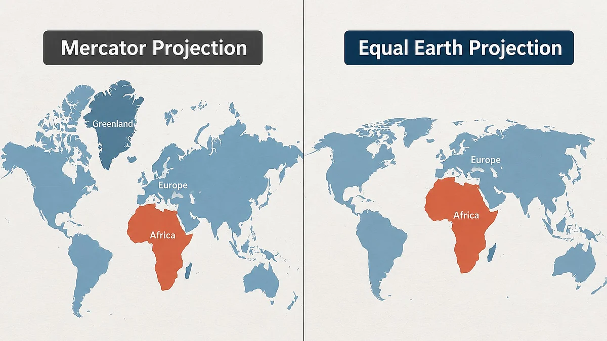


The UN General Assembly has endorsed a new world map designed to represent the relative sizes of continents more accurately, backing an Africa-led campaign to move away from the widely used Mercator projection.
The resolution, sponsored by Togo and supported by African Union members, was approved with 164 countries voting in favour. The United States was the only country to vote against it, while six countries abstained.
The resolution promotes the Equal Earth projection, developed by cartographers in 2018, as a more accurate way of depicting the relative surface areas of continents. It does not legally ban the Mercator projection or make the new map mandatory, but encourages governments and institutions to consider adopting more accurate representations in education and other settings.
Why the Mercator map is controversial
The Mercator projection was developed by Flemish cartographer Gerardus Mercator in 1569, primarily to assist sailors with navigation. Its usefulness for maritime navigation comes from preserving angles and directions, but this comes at the cost of distorting the relative sizes of land masses.
Under the projection, areas farther from the Equator appear disproportionately large, while regions closer to it appear smaller.
The effect is particularly striking in the case of Africa. Greenland can appear roughly comparable in size to the continent on a Mercator map, despite Africa being about 14 times larger. The Equal Earth projection preserves relative surface areas much more accurately.
The distortion has fuelled criticism that the conventional map gives an exaggerated visual prominence to Europe, North America and other northern regions while minimising Africa, South America and other equatorial areas.
‘A fair world begins with a fair map’
Togo led the campaign for the resolution on behalf of the African Union. Before the vote, Togolese Foreign Minister Robert Dussey argued that maps influence how people understand the world.
“A fair world begins with a fair map,” Dussey said.
He also argued that maps are not neutral when they present distorted representations of continents and peoples.
The campaign has been supported by African organisations and advocacy groups seeking to challenge what they describe as longstanding misconceptions about the continent's size, importance and place in the global imagination.
France also backed the initiative. Foreign Minister Jean-Noël Barrot said the country would abandon the Mercator projection in favour of representations more faithful to actual surface areas. France plans to use the Eckert IV projection, which is similar in its approach to Equal Earth.
US opposes resolution
The United States voted against the resolution, with its representative criticising the General Assembly for focusing on a map created centuries ago instead of what Washington considers more pressing global challenges.
The US described the measure as unnecessary and questioned its emphasis on issues such as “cognitive justice”.
The resolution nevertheless passed overwhelmingly.
Because UN General Assembly resolutions of this kind are non-binding, the vote does not mean that every country, school, company or mapping service must immediately replace its existing maps. Instead, it provides international backing for a broader shift towards equal-area projections.
Supporters hope the move will eventually influence maps used in schools, newsrooms, digital platforms and other institutions, changing how generations perceive the relative scale of the world's continents.
Join our official telegram channel (@nationalherald) and stay updated with the latest headlines