Nation
After monsoon havoc, IMD predicts still more heavy rainfall in North India
Himachal and Punjab are already cringing after their recent travails with landslides and flooding; Jammu and Kashmir must be wary too
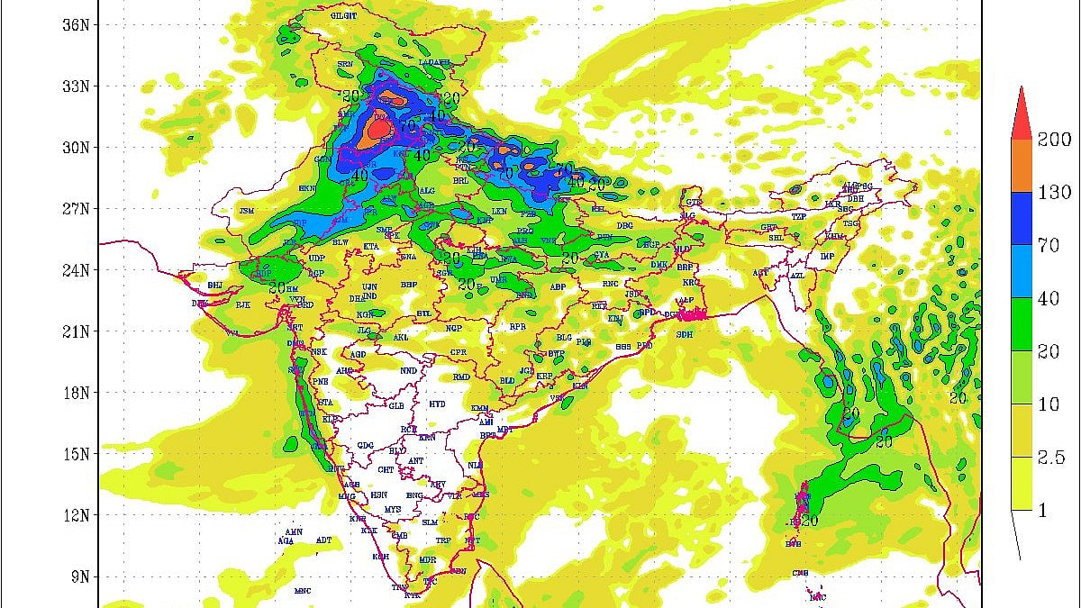
Authorities across North India are bracing for another spell of intense rainfall, with the Indian Meteorological Department (IMD) forecasting a strong western disturbance likely to impact Jammu and Kashmir, Himachal Pradesh, Punjab and parts of Haryana between 4 and 7 October.
The warning has triggered emergency preparedness in states that are still recovering from the devastating floods of August and September.
Punjab remains at the centre of concern, given its vulnerable floodplains and already saturated soil from the monsoon deluge earlier this year.
The IMD has predicted rainfall to the tune of 110 mm in Punjab during the week, with heavy to very heavy rainfall likely on 6–7 October in the districts of Amritsar, Tarn Taran, Gurdaspur, Pathankot, Ropar, Jalandhar, Ludhiana, Moga, Mansa, Barnala and Bathinda.
The state government, wary of a repeat of the recent floods that claimed 59 lives and destroyed crops over nearly 5 lakh acres, has moved to create buffer storage in its major reservoirs. Water outflows from the Ranjit Sagar Dam into the Ravi have been increased significantly — from 20,362 cusecs on 1 October to 37,686 cusecs by 2 October. According to a report in the Tribune, officials hope to keep the water level well below the danger mark of 527.5 feet; it currently stands at 523.53 feet.
Similar precautionary releases are being carried out at the Pong Dam on the Beas, where 17,171 cusecs continue to be discharged.
The state’s water resources department has been in close consultation with the IMD and the Bhakra Beas Management Board to anticipate inflows from upstream catchments. Officials remain especially worried about the 22 rivulets feeding into the Ravi, which could swell dramatically during heavy rainfall events.
The Srinagar Meteorological Centre has also issued a detailed advisory warning of a strong western disturbance between 4 and 7 October, with the system intensifying from the night of 5 October to the morning of 7 October. Jammu and Kashmir is likely to witness widespread light to moderate rain, with the plains of the Kashmir Valley expecting moderate to heavy downpours. The Jammu division could see heavy to very heavy rainfall in isolated pockets, accompanied by thunderstorms, lightning, hailstorms and gusty winds reaching 60–70 km/h.
The union territory also just got its first gust of snow this winter on 3 October in the higher reaches.
In Himachal Pradesh, between 160 and 180 mm of rainfall is predicted, raising fears of landslides and flash floods in the higher reaches as well as rising water levels in the Beas and Sutlej rivers downstream. Authorities have urged residents and tourists to avoid trekking and travel in vulnerable areas during the forecast period.
Haryana too has been brought into the preparedness loop, with the Punjab government formally requesting the irrigation and water resources department to regulate outflows from the Kaushalya Dam in Pinjore on the Ghaggar river. The move is intended to ensure that adequate storage capacity is available to absorb excess inflows and prevent downstream flooding in both Punjab and Haryana.
This fresh spell of inclement weather has left state governments on edge, particularly in Punjab and Himachal Pradesh, which bore the brunt of floods and landslides in recent months. With reservoirs already near capacity and river systems already running at high water, even moderate additional inflows could tip the balance.
Officials across the region are on high alert, holding inter-state and inter-departmental coordination meetings to monitor developments. Citizens, especially in low-lying and flood-prone areas, are being advised to stay vigilant and follow weather updates closely.
If the IMD’s forecast holds true, 6–7 October could prove to be another testing period for the northern states, underscoring the fragile balance between monsoon rains and disaster preparedness in the region.
Meanwhile, the cyclonic weather that has hit Odisha has started a similar cascade of high water level in north coastal Andhra Pradesh as well.
Join our official telegram channel (@nationalherald) and stay updated with the latest headlines