Nation
Odisha on alert as low-pressure over Bay of Bengal triggers heavy rain warning
IMD warns of very heavy rain in Koraput, Malkangiri and parts of south Odisha
Dark monsoon clouds gathered ominously over Odisha on Thursday, 25 September, as the state braced for nature’s next onslaught, with the government placing 18 districts on high alert after the India Meteorological Department (IMD) warned of heavy rains brewing from a low-pressure system over the Bay of Bengal.
Special relief commissioner Deoranjan Kumar Singh held a video conference with district collectors, directing them to take precautionary measures, keep response teams ready and ensure that officials remain stationed at their posts to deal with any emergencies.
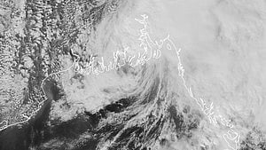
IMD forecast and expected landfall
Bhubaneswar Meteorological Centre director Manorama Mohanty said an upper air cyclonic circulation over the east-central and adjoining northeast Bay of Bengal led to the formation of a low-pressure area at 5:30 pm on Thursday. The system is expected to intensify into a depression by the evening of 26 September and make landfall along the south Odisha–north Andhra Pradesh coasts on the morning of 27 September, she added.
As per the forecast, extremely heavy rainfall is likely in Koraput and Malkangiri, while other districts of south Odisha may also experience heavy to very heavy showers.
Published: undefined
District administrations on alert
Taking note of the warning, the collectors of Koraput, Malkangiri, and Nabarangpur have cancelled all official leaves, instructing government employees not to leave their stations. They have also been asked to stay prepared for possible flooding, landslides, and infrastructure damage.
Collectors in Rayagada, Gajapati, Kalahandi, Ganjam, Puri, Khurda, Jagatsinghpur, Cuttack, Kendrapara, Balasore, and Nuapada have similarly been directed to remain vigilant. The SRC further instructed that ODRAF (Odisha Disaster Rapid Action Force) and Fire Services personnel be deployed in vulnerable pockets ahead of time to ensure swift rescue and relief.
“The state government is closely monitoring the situation. We appeal to the public not to panic,” Singh assured.
Reservoir and flood management
Meanwhile, water resources department engineer-in-chief C.S. Padhi stated that southern Odisha reservoirs are only half-filled and are capable of absorbing the expected rainfall, ruling out an immediate flood threat in the region.
However, water levels in the Mahanadi river system are expected to rise as the Hirakud Dam authorities have opened 20 sluice gates to release excess water. Currently, the dam’s water level stands at 529.15 feet against a full reservoir level (FRL) of 630 feet.
Padhi estimated that around 6 lakh cusecs of water will flow through the Mundali barrage near Cuttack by Friday, which could cause swelling downstream but is being closely monitored.
With PTI inputs
Published: undefined
Join our official telegram channel (@nationalherald) and stay updated with the latest headlines
Published: undefined