Opinion
If not faith, then hope
With the SC mandating a nine-member committee, there is some hope that an effort to save the Aravallis may finally begin
The Aravalli range has played a decisive role in checking the spread of the desert. Its medium-height hills help steer monsoon rain-bearing clouds
If these hills continue to disappear, rainfall patterns in north-west India could change
Dust storms would turn farmland barren, putting farmers’ livelihoods at risk
The Supreme Court has constituted a nine-member committee for the Aravalli range — one of the world’s oldest mountain systems, spread across 37 districts in four states. There is little faith in this committee, but there is still some hope that an effort to save the Aravallis may finally begin. The crisis, in truth, runs deep.
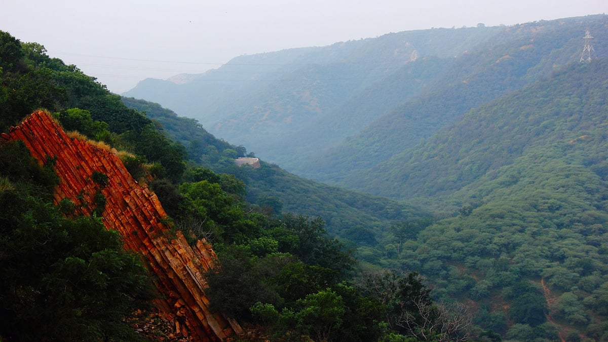
Stretching about 692 km from Khed Brahma in Gujarat, the Aravalli range culminates at Raisina Hill in Delhi, the seat of the country’s most powerful institutions, including Rashtrapati Bhavan. The Aravallis are estimated to be around 650 million years old. Over the past four decades, large parts of the range have not only vanished entirely but, in many places, towering peaks have been replaced by pits nearly 150 feet deep.
To put this in perspective: at the end of the 20th century, around 80 per cent of the Aravallis were covered in greenery; today, that figure has shrunk to barely seven per cent.
As a result, mountain streams and small waterfalls have also disappeared. Leopards, deer and chinkara are increasingly entering human settlements in search of food, leading to a rise in human–wildlife conflict. Strong winds further increase such incursions.
Until now, the Aravallis have played a decisive role in halting the advance of the desert. They have also helped guide monsoon rain-bearing clouds. If these medium-height hills continue to disappear, rainfall patterns in north-west India could change. Already stressed by rising temperatures, these regions could see the 'heat island' effect spread to smaller towns. Dust storms would render agricultural land barren, threatening farmers’ livelihoods.
A study published in the international journal Earth Science Informatics has already warned that the disappearance of hills in the Aravalli range has led to an increase in sandstorms in Rajasthan. Places such as Bharatpur, Dholpur, Jaipur and Chittorgarh are facing more frequent and intense sandstorms than normal.
These are areas where illegal mining, land encroachment and large-scale destruction of greenery in the Aravallis have been particularly severe. The study, conducted by Professor L.K. Sharma of the Central University of Rajasthan and PhD scholar Alok Raj, is titled Assessment of Land Use Dynamics of the Aravalli Using Integrated….
The very survival of Delhi, the non-desert districts of Rajasthan, and much of Haryana depends on the Aravallis. Damage to the range could mean sand dunes advancing as far as Punjab, the country’s grain bowl. For centuries, the Aravallis — rich in greenery and water channels — have acted as a protective shield, preventing sandstorms from reaching fertile and green regions.
Research by ISRO shows that the Thar Desert is no longer confined to Rajasthan and is spreading into several other states. Millions of tonnes of sand rise into the air every day from this vast desert stretching from Rajasthan into Pakistan and beyond. In summer especially, dust blankets the entire region.
Its adverse impact on human life is greater than that of winter smog. Ironically, over the past four decades, human interference and mining have increased so sharply that in many places mountain chains have been replaced by deep ravines — one of the key reasons fertile land is now being overlaid with sand.
The Aravallis have protected large parts of the country from heat and dust storms in two ways. Their higher peaks block PM2.5 particles carried by winds, while lower hills — up to 30 metres high — stop heavier sand and dust particles. According to a Forest Survey of India (FSI) report, even small hills between 10 and 30 metres in height are capable of arresting strong winds and the sand they carry. Since 90 per cent of the Aravallis are less than 100 metres high, permitting mining there would allow desert dust to travel directly to Delhi and the Indo-Gangetic plains (NCR).
The Earth Science Informatics report notes that over the past two decades, at least 31 low- and mid-height hills in the upper Aravalli range across Haryana and northern Rajasthan have completely disappeared. Between 1975 and 2019, 3,676 square kilometres of Aravalli land turned barren. During this period, forest cover declined by 5,772.7 square kilometres (7.63 per cent). If this trend continues, by 2059, concrete jungles could replace 16,360.8 square kilometres (21.64 per cent) of forest land.
Legal and illegal mining in the Aravallis is visible to the naked eye. In recent years, three hills beyond Sohna in Haryana have vanished. Hills near Hodal, near Nangal Dargu in Narnaul, and near Khwaspur in Mahendragarh have also disappeared. Most complaints of illegal night-time mining come from Nuh district, though stone theft is reported across all districts.
The first order banning mining in the Aravallis was issued on 7 May 1992. In 2003, environmentalist M. C. Mehta filed a public interest litigation in the Supreme Court. Numerous orders followed, but as society and governments increasingly viewed mountains merely as land or revenue sources, those fighting to protect them have had to struggle continuously.
In October 2018, when the Supreme Court asked whether 31 of Rajasthan’s 128 hills had been carried away by Lord Hanuman, nothing changed. In September 2019, the Court ordered the Rajasthan government to halt illegal mining within 48 hours on 115.34 hectares of Aravalli hills. The range passes through around 19 districts in Rajasthan, home to over 45,000 legal and illegal mines. Red sandstone mining, carried out with particular ruthlessness, feeds Delhi’s construction needs.
Until recently, the Richard Murphy principle was applied to the Aravallis: hills over 100 metres were classified as Aravalli hills, and mining there was prohibited.
After disputes arose, the Forest Survey of India redefined the range, stating that hills with slopes of up to three degrees would be considered Aravallis, while steeper slopes could be mined. The Rajasthan government argued for a 29-degree threshold. Had the Supreme Court accepted the FSI’s three-degree criterion, mining across 19 districts would have had to stop immediately.
Land mafias have their sights on the entire southern Haryana Aravalli range, especially Gurugram, Faridabad and Nuh. Much of the land was bought years ago. Once forest protection laws are weakened, non-forest activities will begin. At present, such activities are barred: where forest laws apply, only government development works are permitted—not even housing for officials.
In a September 2018 ruling, the Supreme Court held that land covered under the Punjab Land Preservation Act (PLPA), 1900, would be treated as forest land. On this basis, the Court ordered the demolition of all buildings in Faridabad’s Kant Enclave colony. When officials were pressured to implement a 7 June 2021 order, nearly 10,000 houses spread over 80 acres in Khori village near Surajkund were demolished, leaving around 60,000 people homeless. Yet on 22 October 2021, the Haryana government told the Court that the 2018 ruling was flawed and could not be fully implemented.
More recently, after the Supreme Court permitted mining on hills under 100 metres, the Haryana Shahari Vikas Pradhikaran quietly regularised numerous constructions in the Aravalli forest area. The Forest Advisory Committee of the Union environment ministry granted in-principle approval to government and semi-government constructions on 67.68 hectares of Aravalli forest land, effectively shielding them from demolition. These ex post facto clearances were granted under a diversion policy for constructions already existing in PLPA-notified forest areas.
Between 20 November and 29 December, the government not only awarded new mining contracts but also legalised constructions worth billions owned by influential individuals. Under the PLPA, 1900, 1,739,907 hectares of land lie in the foothills of the Aravallis, covering Gurugram, Faridabad, Palwal, Ambala, Panchkula, Yamunanagar, Rewari, Bhiwani, Charkhi Dadri, Mahendragarh and Mewat. On paper, restrictions apply across these areas—but only on paper.
Pankaj Chaturvedi is editor, www.indiaclimatechange.com. More of his writing may be read here
Join our official telegram channel (@nationalherald) and stay updated with the latest headlines