Nation
Delhi’s elevated infra projects disrupt water flow: Drainage Master Plan
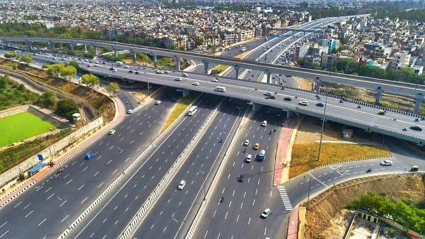
Towering infrastructure designed to ease congestion, such as the Western Peripheral Expressway, a key contributor to disruption
Ambitious efforts to reduce traffic congestion in the national capital — including elevated roads, metro expansions, and the proposed elevated Ring Road — are having an unintended impact on Delhi’s natural drainage system, according to the city’s newly unveiled Drainage Master Plan.
The comprehensive plan, recently released by the government, outlines a long-term vision to tackle the city’s chronic waterlogging problem over the next 30 years.
At an estimated cost of around Rs 57,000 crore, it highlights the urgent need for ‘water-sensitive’ planning to ensure sustainable urban development.
Towering infrastructure designed to ease congestion, such as the Western Peripheral Expressway, is now being recognised as a key contributor to disrupted water flow, especially in low-lying basins.
“The existing Western Peripheral Expressway has significantly impacted the flow patterns within the Najafgarh basin,” the master plan states.
Though the 135-km expressway, located in Haryana, was constructed to divert heavy traffic away from Delhi and reduce air pollution, it has altered regional hydrological patterns with direct consequences for the capital’s water management systems.
To mitigate such risks, the plan calls for integration of drainage considerations in the early design stages of all major infrastructure projects. It also recommends aligning future development with modern water and sewage management strategies.
“The focus on water-sensitive spatial planning and incorporating 'Blue-Green' infrastructure is essential for promoting sustainable and resilient urban development,” the document adds.
Earlier this year, as part of its Delhi decongestion initiative, the government proposed a 55-km elevated Ring Road (Mahatma Gandhi Marg) and tasked the Public Works Department (PWD) with preparing a detailed project report. However, the master plan cautions that such mega infrastructure could carry environmental risks.
“Developing an elevated Ring Road and expanding the Delhi Metro could alter water flows, leading to waterlogging and increased flooding,” the report, authored by urban infrastructure experts, warns.
PWD officials have confirmed that a feasibility study is under way for the elevated corridor, which would run through densely populated urban zones and form a critical part of Delhi’s road network.
Experts argue that even if some infrastructure lies outside city limits, their hydrological impact cannot be dismissed.
“While the Western Peripheral Expressway is in Haryana and might not directly affect the city’s stormwater drainage system, during the construction of projects like the elevated Ring Road, all parameters for the drainage network under the flyover will have to be considered,” said S. Velmurugan, chief scientist at the Central Road Research Institute (CRRI).
The master plan divides Delhi into three drainage basins: Najafgarh, Barapullah, and Trans-Yamuna. In each, the current drainage infrastructure — most of it over 50 years old — is struggling to cope with the effects of rapid urbanisation.
The report serves as a reminder that modern infrastructure cannot be planned in isolation from natural systems. As the capital races to modernise, the challenge will be to balance development with environmental resilience — ensuring that progress does not come at the cost of increased flooding and disrupted urban water cycles.
With PTI inputs
Join our official telegram channel (@nationalherald) and stay updated with the latest headlines